SYCAMORE ISLAND CLUB
|
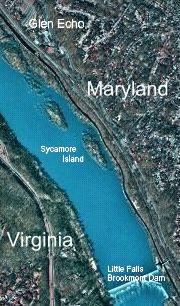
The Sycamore Island Club is located on Sycamore Island, an island in the Potomac River, south of the American Legion Bridge (the beltway bridge connecting Virginia's Fairfax County and Maryland's Montgomery County) and north of Chain Bridge (the northernmost bridge connecting Virginia's Arlington County to Washington, DC). It is in the general vicinity of the town of Glen Echo. The island is accessible only from the Maryland side of the river by parking at either the parking lot on MacArthur Boulevard or the parking lot on the Clara Barton Parkway. From either parking lot, a footpath can be found leading down to the river and to Sycamore Island.
TO THE MacARTHUR BOULEVARD PARKING LOT
From downtown Washington, DC through Georgetown ...
Leave west out of Georgetown on M street past Key Bridge
and the entrance to the Whitehurst Freeway. Take your
second left onto MacArthur Boulevard and continue about 4
miles to a parking lot on your left, across the street
from Walhonding Road. (If you come to the small traffic
circle at the Glen Echo Shopping Center, you have gone too
far.) Find the footpath leading (over a spiral pedestrian
overpass) down to the river.
From downtown Washington, DC on Massachusetts Avenue
...
Follow Massachusetts Avenue out of Washington, DC until it
dead-ends at Goldsboro Road. Turn left onto Goldsboro Road
and follow it to a small traffic circle at MacArthur
Boulevard (the Glen Echo Shopping Center should be on your
right). Go 3/4 around the circle and head south on
MacArthur Boulevard. Stay on MacArthur Boulevard through
the stop sign for the entrance to the Clara Barton
Parkway. Continue to a parking lot on your right, across
the street from Walhonding Road. Find the footpath leading
(over a spiral pedestrian overpass) down to the river.
From the Capital Beltway...
Take the River Road exit from the Capital Beltway (495)
south towards Washington, DC (and Bethesda). Turn right at
the 5th traffic light onto Goldsboro Road. Follow
Goldsboro Road to a small traffic circle at MacArthur
Boulevard (the Glen Echo Shopping Center should be on your
right). Go 3/4 around the circle and head south on
MacArthur Boulevard. Stay on MacArthur Boulevard through
the stop sign for the entrance to the Clara Barton
Parkway. Continue to a parking lot on your right, across
the street from Walhonding Road. Find the footpath leading
(over a spiral pedestrian overpass) down to the river.
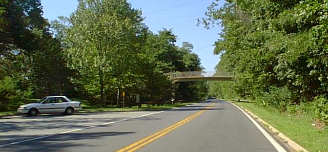 |
| Pedestrian Overpass |
TO THE CLARA BARTON PARKWAY PARKING LOT
Landmark: PEDESTRIAN OVERPASS
The Clara Barton Parkway is a major commuter artery in
and out of Washington. As such, it is only one-way
inbound on weekday mornings and only one-way outbound on
weekday afternoons.
(DO NOT use the following route between 6:15 a.m. and
10:00 a.m. on weekday mornings! Both lanes of the
Parkway are used for inbound traffic to downtown
Washington, DC. Use directions from downtown to the
MacArthur Boulevard parking lot instead.)
From downtown Washington, DC...
Leave west out of Georgetown on M street past Key Bridge
and the entrance to the Whitehurst Freeway. Take your
first left onto Canal Road which follows directly west and
north along the river (very scenic). After about 2 miles,
Canal Road becomes Clara Barton Parkway just past the turn
for Chain Bridge. Continue on the Clara Barton Parkway
about 2 more miles, past the Little Falls Brookmont Dam
(on your left), and park at the parking lot at the
pedestrian overpass. Find the footpath leading down to the
river.
(Note: There is a pedestrian overpass on the parkway
between Chain Bridge and the Brookmont Dam. This is NOT
the overpass near Sycamore Island.)
(DO NOT use the following routes between 2:45 p.m. and
7:00 p.m. on weekday afternoons! Both lanes of the
Parkway are used for outbound traffic from downtown
Washington, DC. Use beltway directions to the MacArthur
Boulevard parking lot instead.)
From the Capital Beltway...
From Virginia ... as you cross the Potomac River
into Maryland take the right exit marked "Clara Barton
Parkway" off the American Legion Bridge. Once on the
parkway and heading towards DC, make no turns and stay in
the right lane. Just after the parkway changes from a
divided highway to a single lane highway look for a
pedestrian overpass. Park in the parking lot adjacent to
the pedestrian overpass and find the footpath leading down
to the river.
From Maryland ... take the exit marked "Cabin John"
(IMMEDIATELY after the River Road exit). Follow the
connecting highway which merges into the Clara Barton
Parkway after about 1 mile. Once on the parkway make no
turns and stay in the right lane. Just after the parkway
changes from a divided highway to a single lane highway
look for a pedestrian overpass. Park in the parking lot
adjacent to the pedestrian overpass and find the footpath
leading down to the river.
The footpaths from both parking lots
converge at a bluff looking down over the Potomac River
and Sycamore Island. The path then leads down the slope to
an old steel bridge over the C & O Canal, and on to
the canal's towpath. Shortly up ahead on the towpath you
will find steps leading down into the river and ropes
going over to Sycamore Island. Yanking on one of the ropes
rings a cowbell on the Island and is a signal to alert the
caretaker.
A parking lot for Lock 7 is on the inbound Clara Barton Parkway.
The six-tenths of a mile walk takes about 12 minutes while the trail from MacArthur Blvd. takes about 5 minutes downhill and 7 minutes uphill.